
DORIAN SMASHES BAHAMAS AS CATEGORY 5 HURRICANE
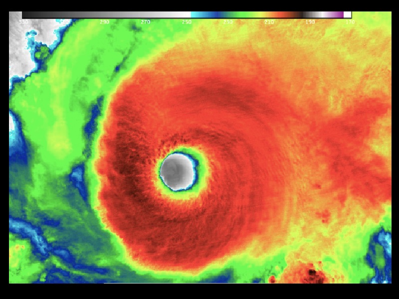
Hurricane Dorian struck the northern Bahamas as a catastrophic Category 5 storm yesterday. The storms record 185 m.p.h. winds ripping off roofs, overturning cars and tearing down power lines as hundreds hunkered down in schools, churches and shelters.
Officials in the Bahamas say they are getting “reports of bodies being seen” today as slow-moving Hurricane Dorian continues to wreak havoc on the island nation, forcing first responders and residents to take cover.
The now Category 4 storm currently is moving across Grand Bahama Island at just 1 mph – and crews hoping to get a better assessment of the “catastrophic damage” reported in regions like the Abacos are still waiting for conditions to clear up, Foreign Minister Darren Henfield said.
“We have reports of casualties. We have reports of bodies being seen,” he said. “We cannot confirm those reports until we go out and have a look for ourselves.”
“We want to say to the citizens here in Abaco, in the impacted area, it is not safe to go outdoors,” Henfield added. “Power lines are down, lamp posts are down, trees are across the street – it is very dangerous to be outdoors if you don’t have to be outdoors. As soon as the weather permits, first responders will go to those areas where we have reports from individuals who were in distress.”
The National Hurricane Center (NHC) downgraded the storm to a Category 4 late this morning. As of 2 p.m. eastern, its eye was located about 25 miles northeast of Freeport on Grand Bahama Island and 105 miles east of West Palm Beach, Florida.
Hurricane watches and warnings are now in place for much of the east coast of Florida, Evacuations are ordered for many areas including parts of Jacksonville, Florida.
The NHC says wind gusts of up to 190 m.p.h. were reported today in Grand Bahama Island, where storm surge is expected to bring water “18 to 23 feet above normal tide levels”.
Over the next day or so, Dorian is expected to make a “slow westward to west-northwestward motion” followed by a “gradual turn toward the northwest and north”, the NHC says.
“The hurricane will move dangerously close to the Florida east coast tonight through Wednesday evening,” it added, where a number of hurricane warnings and watches remain in effect.