MANDATORY EVACUATION OF KEY WEST AS WELL AS VOLUNTARY EVACUATIONS IN SOUTHERN FLORIDA BEGIN TO PREPARE FOR IRMA
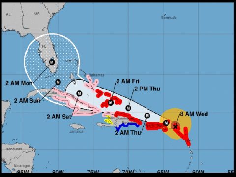
Story note – This picture of the track of Irma is from the National Hurricane Center as of 7 a.m. Wednesday, September 6, 2017. On its projected course as of now, Irma will hit Key West and southern Florida Sunday night (September 10, 2017), be over Disneyworld by sunrise Monday (September 11, 2017) and around Jacksonville, Florida by late Tuesday (September 12, 2017). Irma is projected to be a major hurricane during this time. We will continue to update this with a new story each day until Irma leaves the southeast so ones that have friends in family in Florida can stay informed.
The most powerful Atlantic Ocean hurricane in recorded history made its first landfall, over the islands of the northeast Caribbean early Wednesday, churning along a path pointing to Puerto Rico, the Dominican Republic, Haiti and Cuba before possibly heading for Florida over the weekend.
The U.S. National Hurricane Center, in Miami, called Hurricane Irma “potentially catastrophic.” It was a Category 5 storm, the most powerful there is.
Irma’s eye passed over Barbuda around 1:47 a.m., the National Weather Service said. Residents said over local radio that phone lines went down. Heavy rain and howling winds raked the neighboring island of Antigua, sending debris flying as people huddled in their homes or government shelters.
Irma ripped the roof off Barbuda’s police station, forcing officers to seek refuge in the nearby fire station and at the community center that served as an official shelter. The storm also knocked out communication between islands. Midcie Francis, of the National Office of Disaster Services confirmed there was damage to several homes, but said it was too early to do tally or assess the extent of the damage.
Foreign Affairs Minister Charles Fernandez, who has temporary oversight for Disaster Management, told The Associated Press via text that the northern end of island was hit hard by the storm. He didn’t elaborate on the extent of damage.
By 5 a.m., the storm was moving away from Barbuda and toward St. Martin, the center said. Later, French meteorological authorities said Irma had reacehed St. Barts and St. Martin.
Officials warned people to seek protection from Irma’s “onslaught” in a statement that closed with, “May God protect us all.”
The Category 5 storm had maximum sustained winds of 185 mph early Wednesday, according to the hurricane center. Irma was some 35 miles east-southeast of St. Martin and 145 miles east of St.Croix, moving west-northwest at 16 mph, the center said.
The center’s forecast was for the winds to fluctuate slightly but for the storm to remain at Category 4 or 5 strength for the next day or two. The most dangerous winds, usually nearest to the eye, were forecast to pass near the northern Virgin Islands and near or just north of Puerto Rico through the day Wednesday.
French authorities ordered inhabitants to remain confined to their houses and not to go out under any circumstances in the French Caribbean islands of Saint Martin and Saint Barthelemy because of Irma.
The storm seemed almost certain to hit the United States by early next week.
“You’d be hard pressed to find any model that doesn’t have some impact on Florida” said University of Miami senior hurricane researcher Brian McNoldy.
In Florida, people were stocking up on drinking water and other supplies.
Lines for gasoline stretched around 50 cars deep at a gas station in Cooper City, which is southwest of Fort Lauderdale, by 5:30 a.m. Wednesday. The station had been out of fuel on Tuesday night, but received an overnight delivery.
Workers at a station in Doral, near Miami, put yellow caution tape around pumps Wednesday morning after running out of gasoline. Local news outlets reported both long lines and stations that had no gas across South Florida.
Governor Rick Scott activated 100 members of the Florida National Guard to be deployed across the state, and 7,000 National Guard members were to report for duty Friday, when the storm could be approaching the area. On Monday, Scott declared a state of emergency in all of Florida’s 67 counties.
Officials in the Florida Keys will get tourists out of Irma’s path Wednesday and residents on Thursday, and the mayor of Miami-Dade county said people should be prepared to evacuate Miami Beach and most of the county’s coastal areas.
Mayor Carlos Gimenez said the voluntary evacuations could begin as soon as Wednesday evening. He activated the emergency operation center and urged residents to have three days’ worth of food and water.
Miami Beach Mayor Philip Levine said, “If you can, begin making plans now to leave Miami Beach. This is so serious. There are so many people that may want to get off this island.”
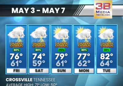
Once Irma makes its way north, it is expected to bring heavy rains and winds to the Carolinas and Tennessee early next week.


