

NATIONAL WEATHER SERVICE SAYS NOT ONE BUT THREE DERECHO TYPE STORM LINES HIT THE REGION MEMORIAL DAY WEEKEND
The National Weather Service said today (Wednesday, May 31, 2017) that not one but three derecho systems hit the regional last Saturday night (May 27, 2017) Memorial Day weekend. The strongest one struck the listening area with up to 90 mile per hour winds causing widespread destruction. Some of the listening area still remains without power today (Wednesday, May 31, 2017) mainly in areas of Roane County, Tennessee.
So what exactly is this weather phenomenon? Here are some quick facts about derechos:
What is a derecho?
A derecho is a widespread, long-lived wind storm associated with a band of rapidly moving showers or thunderstorms variously known as a squall line, bow echo, or quasi-linear convective system. Although a derecho can produce destruction similar to that of a tornado, the damage typically occurs in one direction along a relatively straight swath. As a result, the term “straight-line wind damage” sometimes is used to describe derecho damage.
How strong are derecho winds?
By definition, a derecho must include wind gusts of at least 58 mph (50 knots or 93 km/h) or greater along most of its length. While derecho winds typically are less than 100 mph, gusts as high as 130 mph have been recorded — equivalent to those with strong EF2 tornadoes.
What are the dimensions of a derecho?
A derecho wind damage swath must extend more than 240 miles (about 400 kilometers). This criterion is used to eliminate more common, shorter-lived, and generally less-organized wind-producing convective systems. Although no formally-recognized width criterion exists for a derecho, the nature of the storm systems responsible for their development dictates that most derechos span at least 50 miles (80 km) in width.
What is the origin of the term “derecho?”
The word “derecho” was coined by Dr. Gustavus Hinrichs, a physics professor at the University of Iowa, in a paper published in the American Meteorological Journal in 1888. “Derecho” is a Spanish word meaning “direct” or “straight ahead;” Hinrichs coined it to distinguish straight-line wind damage from that produced by tornadoes. While the term was used in the meteorological community for a short time during the late nineteenth century, it disappeared from use for nearly 100 years until resurrected by severe weather meteorologists in the mid-1980s.
Can derechos be recognized by characteristic cloud formations or the general appearance of the sky?
The atmospheric conditions (moisture, temperature, and winds) that determine how and when clouds form and what shape they take vary markedly in derecho environments. As a result, the appearance of an impending derecho-producing storm typically varies from one event to the next, and over time during the life of a given event. Variations in the background lighting by the sun (determined by time of day, season, degree of atmospheric clarity, etc.) also affect the appearance of approaching storms. Many derechos are, however, preceded by ominous-looking “shelf” clouds that form in the zone of rapidly rising air on the leading edge of the storm system’s outflow winds. In addition, derecho-producing storms tend to appear darker than most, especially when viewed from the ground during the late afternoon or early evening.
Who is most at risk from a derecho?
Those outdoors are most at risk in a derecho. Campers or hikers in forested areas are vulnerable to being injured or killed by falling trees, and people at sea risk injury or drowning from storm winds and waves that can overturn boats. Occupants of cars and trucks also are vulnerable to falling trees and utility poles. High profile vehicles such as semi-trailer trucks, buses, and sport utility vehicles may be blown over. At outside events such as fairs and festivals, people may be killed or injured by collapsing temporary structures and flying debris. Even those indoors may be at risk for death or injury. Mobile homes, in particular, may be overturned or destroyed, while barns and similar buildings can collapse. People inside homes, businesses, and schools are sometimes victims of falling trees and branches that crash through walls and roofs; they also may be injured by flying glass from broken windows. On occasion, severe structural damage to buildings (for example, the removal of a roof) pose danger to those within.
What special hazards are posed by derechos to cities?
While those out-of-doors, whether in rural areas or elsewhere, are at greatest risk in a derecho, derechos pose a special hazard to those in cities. It is the vulnerability of overhead electric and communication lines to high winds and falling trees that makes derecho winds especially problematic in urban areas. In addition to posing a direct hazard to anyone caught below the falling lines, derecho damage to overhead electrical facilities sometimes results in massive, long-lasting power outages that can affect hundreds of thousands of people; in the worst events, power may not be restored for days. The complex and dense networks of overhead distribution lines — and their proximity to large trees — make urban and suburban areas especially vulnerable to significant derecho-induced electrical and communication outages. In addition, unlike the localized damage produced by a tornado, derecho damage may be widespread, with repairs requiring considerably more time and effort to accomplish.
What can one do to prepare for a derecho?
If planning to be outdoors for a significant length of time, be aware of the weather forecast — especially if you will be well-removed from sturdy shelter. Stay “connected” via television, radio, NOAA Weather Radio, or social media. Derechos rarely occur without warning, although warning lead times may be comparatively limited during the early stages of storm development. Because protracted and extensive electrical and communication disruptions may occur, set aside emergency water and food supplies, can openers, batteries, and flash lights. As with a hurricane, be aware that hotel and motel facilities may be impacted after the event, and that gasoline availability may be limited over a broad area.
What can one do if caught out-of-doors?
Falling debris is the most serious hazard posed by a derecho to those without shelter; cloud-to-ground lightning strikes are an additional hazard. Lie flat and face-down on low ground, protecting the back of your head with your arms. If possible, avoid trees; even relatively small branches can become lethal when blown by storm winds.
What can one do to after a derecho?
If you suffer a power outage from a derecho, do not assume that the utility responsible for your area is aware of the problem. Although some utilities are equipped with automated devices that relay information regarding the location and duration of outages to operational centers, many service providers are not so equipped. If possible, contact your utility with information about the outage. In the mean time, avoid any downed power lines and, especially, contact with lines in wet areas; the wires could still be “live.” Also watch for broken glass, upstanding nails, partially fallen tree limbs, and other hazardous debris. A sizable number of injuries and deaths related to derechos occur during clean-up operations — long after the storm has passed.
How might climate change affect derecho frequency and distribution?
The short answer is: No one can be sure. A warmer planet at first glance would appear to be more conducive to the development of the intense thunderstorms that comprise derecho-producing convective systems. But thunderstorm updrafts require the presence of strong
vertical temperature gradients; any warming occurring at the surface likely also would occur aloft. Thus, the net change in instability due to thermal changes likely would be minimal. And, although a warmer environment implies greater atmospheric moisture content and conditional instability (instability related to the release of latent heat during condensation), all other factors remaining equal, the increased moisture likely also would yield more widespread low-level cloud cover. Such cloudiness would negatively impact storm initiation and derecho development. What is more certain is that the band of enhanced upper-level flow that encircles the planet the jet stream would contract poleward in a warmer world. Because derechos tend to form on the equatorward side of the jet stream along the northern fringes of warm high pressure (“fair weather”) systems, it is reasonable to conclude that the corridors of maximum derecho frequency would shift poleward with global warming.

Related Posts
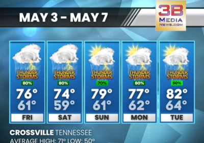
FRIDAY’S 5-DAY FORECAST
The risk for severe weather this weekend is low, but we could see heavy downpours…
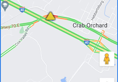
MULTI VEHICLE CRASH BACKS UP TRAFFIC AT CRAB ORCHARD
CROSSVILLE - A multi vehicle accident at A256 Hwy 70 Access Road, Westbound at Crab…

THURSDAY’S 5-DAY FORECAST
Above normal temperatures with rain and storm chances in the forecast. Thursday: Sunny, with a high…