

FLASH FLOOD WATCH ISSUED FOR UPPER CUMBERLAND REGION
Along with a wind advisory, the National Weather Service has issued a FLASH FLOOD WATCH from noon central today (Sunday, April 12, 2020) until tomorrow
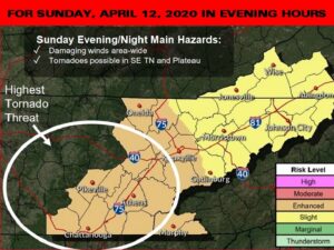
NATIONAL WEATHER SERVICE: TORNADOES POSSIBLE IN COVERAGE AREA EASTER NIGHT
The National Weather Service there is a high threat for tornadoes in parts of the coverage area late tomorrow afternoon into the evening hours (Sunday,
FREEZE WATCH ISSUED FOR UPPER CUMBERLAND AREA
The National Weather Service has issued a FREEZE WATCH from late tomorrow night (Friday, April 10, 2020) until mid-Saturday morning (April 11, 2020). The watch
NATIONAL WEATHER SERVICE: FINAL REVIEW OF STORM DAMAGE UNDERWAY
The National Weather Service issued another report today regarding the damage caused early Sunday morning from either a tornado or straight line winds. In White
RAIN AND COOL TUESDAY
Rain and cool are the words for Tuesday, not the words I wanted to use but sometimes you just have to tell it like it
SEVERE STORMS BLAST COVERAGE AREA – DAMAGE REPORTED IN CUMBERLAND, WHITE, FENTRESS AND MORGAN COUNTIES
A line of severe thunderstorms around 2:30 a.m. this morning left a trail of destruction in Cumberland, White, Fentress and Morgan County. The National Weather
FLASH FLOOD WATCH ISSUED FOR SOUTHERN PART OF COVERAGE AREA
The National Weather Service has issued a FLASH FLOOD WATCH from 8 a.m. central today (Tuesday, March 24, 2020) until late this evening. The watch

TORNADO SIRENS IN CUMBERLAND COUNTY…WHY ONLY THREE AND NOT MORE?
Story by Scott Humphrey, News Director After the tornadoes in the early morning hours of March 3, 2020, many residents of Cumberland County asked 105.7
BETTER WEATHER AFTER A DEVASTATING NIGHT
After a violent night of weather across Tennessee things are looking much better for our election day. Partly sunny skies today through Wednesday with high
GOOD WEEKEND THEN HEAVY RAIN
Light Snow tonight but clearing Skies will move in early Saturday morning and the remainder of the weekend is looking great. High temperatures in the
SNOW THEN SUN FOR THE WEEKEND
A winter weather advisory from 4 a.m. Friday morning until noon for the possibility of 1 to 2 inches of snow. There could be hazardous
WINTER WEATHER ADVISORY IN EFFECT FOR PART OF COVERAGE AREA
The National Weather Service has issued a WINTER WEATHER ADVISORY for the following counties: CUMBERLAND, FENTRESS, OVERTON, PICKETT, PUTNAM, WHITE AND VAN BUREN The advisory

FLASH FLOOD WATCH ISSUED FOR UPPER CUMBERLAND REGION
Along with a wind advisory, the National Weather Service has issued a FLASH FLOOD WATCH from noon central today (Sunday, April 12, 2020) until tomorrow morning (Monday April 13, 2020) for the followin ...

NATIONAL WEATHER SERVICE: TORNADOES POSSIBLE IN COVERAGE AREA EASTER NIGHT
The National Weather Service there is a high threat for tornadoes in parts of the coverage area late tomorrow afternoon into the evening hours (Sunday, April 12, 2020). The weather service added the s ...

FREEZE WATCH ISSUED FOR UPPER CUMBERLAND AREA
The National Weather Service has issued a FREEZE WATCH from late tomorrow night (Friday, April 10, 2020) until mid-Saturday morning (April 11, 2020). The watch includes the following counties in the c ...
NATIONAL WEATHER SERVICE: FINAL REVIEW OF STORM DAMAGE UNDERWAY
The National Weather Service issued another report today regarding the damage caused early Sunday morning from either a tornado or straight line winds. In White County, a small EF-0 tornado touched d ...
RAIN AND COOL TUESDAY
Rain and cool are the words for Tuesday, not the words I wanted to use but sometimes you just have to tell it like it is. I think the high temperature will only be in the 40s and the Northeast wind at ...
SEVERE STORMS BLAST COVERAGE AREA – DAMAGE REPORTED IN CUMBERLAND, WHITE, FENTRESS AND MORGAN COUNTIES
A line of severe thunderstorms around 2:30 a.m. this morning left a trail of destruction in Cumberland, White, Fentress and Morgan County. The National Weather Service issues a tornado watch for Cumb ...
FLASH FLOOD WATCH ISSUED FOR SOUTHERN PART OF COVERAGE AREA
The National Weather Service has issued a FLASH FLOOD WATCH from 8 a.m. central today (Tuesday, March 24, 2020) until late this evening. The watch includes the following counties in the coverage area: ...

TORNADO SIRENS IN CUMBERLAND COUNTY…WHY ONLY THREE AND NOT MORE?
Story by Scott Humphrey, News Director After the tornadoes in the early morning hours of March 3, 2020, many residents of Cumberland County asked 105.7 News why there are hardly any tornado sirens in ...
BETTER WEATHER AFTER A DEVASTATING NIGHT
After a violent night of weather across Tennessee things are looking much better for our election day. Partly sunny skies today through Wednesday with high temperatures in the low 60s and the low toni ...
GOOD WEEKEND THEN HEAVY RAIN
Light Snow tonight but clearing Skies will move in early Saturday morning and the remainder of the weekend is looking great. High temperatures in the low 40s on Saturday and mid-50s on Sunday with sun ...
SNOW THEN SUN FOR THE WEEKEND
A winter weather advisory from 4 a.m. Friday morning until noon for the possibility of 1 to 2 inches of snow. There could be hazardous travel during the morning but temperatures climbing to 40 in the ...
WINTER WEATHER ADVISORY IN EFFECT FOR PART OF COVERAGE AREA
The National Weather Service has issued a WINTER WEATHER ADVISORY for the following counties: CUMBERLAND, FENTRESS, OVERTON, PICKETT, PUTNAM, WHITE AND VAN BUREN The advisory starts at 4 a.m. centra ...