
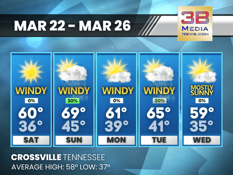
WEEKEND STARTS SUNNY, ENDS WITH RAIN CHANCES
Sunny skies and 60s Saturday and Sunday give way to gusty winds, showers, and possible thunderstorms late Sunday before cooler, breezy weather returns for the workweek. Saturday: Sunny, with a high ...

SPRING ARRIVES WITH A CHILL
Thursday starts the season with clouds, gusty winds, and a chance of rain and snow, but sunshine and warmer temperatures take over by Friday and Saturday. Thursday: First Day of Spring. A slight ch ...

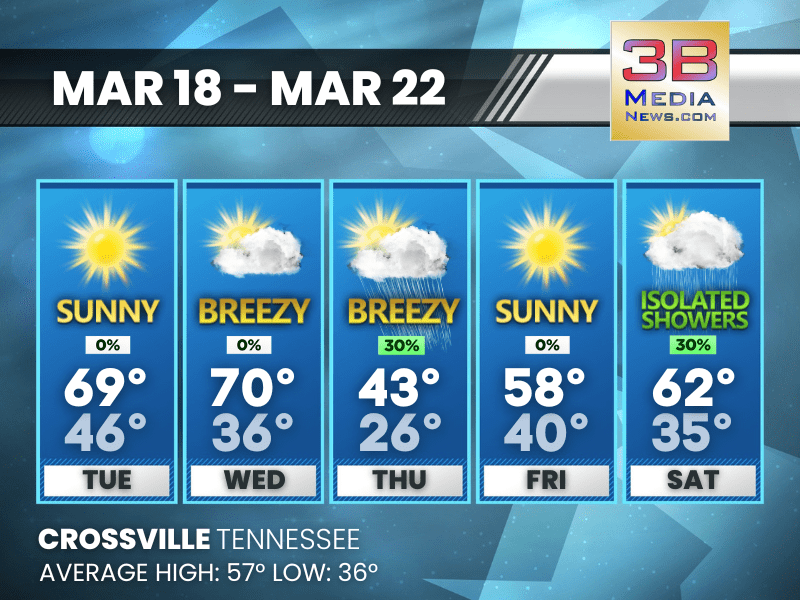
SPRING STARTS WITH A WEATHER ROLLERCOASTER!
Mild and breezy Wednesday gives way to rain, a cold snap, and a chance of snow Thursday—before sunshine and warmer temps return for the weekend. Wednesday: Partly sunny, with a high near 71. South ...

WIND ADVISORY EXPANDED ACROSS EAST TENNESSEE
The National Weather Service has expanded a Wind Advisory to cover much of East Tennessee, warning residents to brace for strong winds that could lead to power outages, downed trees, and hazardous dri ...

WIND ADVISORY ISSUED FOR CUMBERLAND, PICKETT, AND FENTRESS COUNTIES WEDNESDAY
The National Weather Service in Nashville has issued a Wind Advisory for all of Middle Tennessee, including Cumberland, Pickett, and Fentress Counties, in effect from 10:00 AM to 10:00 PM CDT on Wedne ...
SPRING ARRIVES WITH A WEATHER WHIPLASH—FROM 70s TO SNOWFLAKES!
Warm and breezy midweek gives way to thunderstorms, a chilly First Day of Spring, and even a chance of rain and snow showers before sunshine returns for the weekend. Tuesday: Sunny, with a high nea ...

SPRING TEASE: WARMING UP BEFORE A STORMY MIDWEEK COOL-DOWN
Sunny and mild through Wednesday, then showers, storms, and a big temperature drop to kick off spring. Today: Sunny, with a high near 53. North northwest wind 5 to 10 mph. Tonight: Mostly clear, ...

TORNADO WATCH ISSUED UNTIL 9 P.M.
TORNADO WATCH 47 REMAINS VALID UNTIL 9 PM CDT THIS EVENING FOR THE FOLLOWING AREAS IN TENNESSEE THIS WATCH INCLUDES 14 COUNTIES IN MIDDLE TENNESSEE CANNON CLAY COFFEE CUMBERLAND DE KALB FENTRESS GRUND ...

TORNADO WARNING ISSUED FOR CROSSVILLE
At 555 PM CDT, a severe thunderstorm capable of producing a tornado was located near Crossville, moving northeast at 60 mph. HAZARD...Tornado. SOURCE...Radar indicated rotation. IMPACT...Flying debris ...

SEVERE THUNDERSTORM WARNING ISSUED
The National Weather Service in Nashville has issued a * Severe Thunderstorm Warning for... Overton County in Middle Tennessee... Pickett County in Middle Tennessee... Northwestern Cumberland County i ...
TORNADO WARNING ISSUED
The National Weather Service in Nashville has issued a * Tornado Warning for... Northwestern Cumberland County in Middle Tennessee... Central White County in Middle Tennessee... Southeastern Putnam Co ...

TORNADO WATCH UNTIL 9 P.M.
THE NATIONAL WEATHER SERVICE HAS ISSUED TORNADO WATCH 47 IN EFFECT UNTIL 9 PM CDT THIS EVENING FOR THE FOLLOWING AREAS IN TENNESSEE THIS WATCH INCLUDES 34 COUNTIES IN MIDDLE TENNESSEE BEDFORD CANNON C ...