

WIND ADVISORY ISSUED FOR MIDDLE TENNESSEE
The National Weather Service has issued a Wind Advisory for Cumberland, Pickett, and Fentress counties from 10:00 PM CDT tonight until 7:00 AM CDT Saturday.

FLOOD WATCH ISSUED FOR MULTIPLE COUNTIES THIS WEEKEND
From the Crossville/Cumberland County Emergency Management Agency: WHAT…Flooding caused by excessive rainfall is possible. * WHERE…A portion of Middle Tennessee, including the following counties, Bedford,

TENNESSEANS URGED TO TAKE STEPS AHEAD OF SEVERE STROM THREAT
NASHVILLE, Tenn. – The Tennessee Emergency Management Agency (TEMA) encourages all Tennesseans to monitor National Weather Service forecasts and take preparedness steps as multiple rounds of significant
SEVERE STORMS, TORNADO THREAT THIS WEEKEND
Severe thunderstorms expected Friday night through early Saturday morning, as well as Saturday afternoon and evening. Storms will pose a threat for damaging winds, large
STRONG THUNDERSTORM NEAR SPENCER; HAIL REPORTED
From the Crossville/Cumberland County Emergency Management Agency: At 101 PM CDT, Doppler radar was tracking a strong thunderstorm near Spencer, moving northeast at 15 mph.

SEVERE WEATHER THREAT THIS WEEKEND
A strong low-pressure system is set to bring severe weather to Middle and East Tennessee from Friday evening through Saturday night, with the potential for
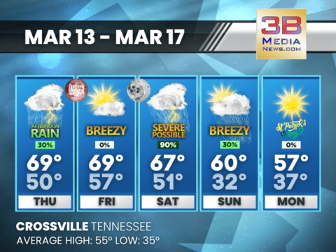
STORMY WEEKEND AHEAD WITH SEVERE WEATHER POSSIBLE
A chance of showers Thursday, then a total lunar eclipse overnight—heavy rain and strong storms likely Saturday into Sunday before a cooler, sunny start to
SEVERE WEATHER UPDATE
Severe weather remains a concern for late Saturday, though some uncertainty still exists regarding the exact details. However, the latest trends indicate an increasing potential
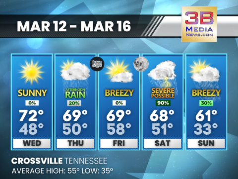
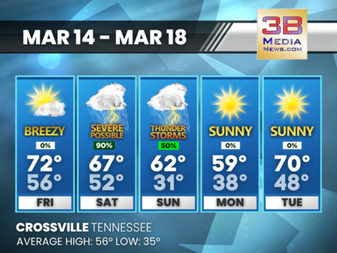
WARM & SUNNY NOW – STORMS ARRIVE THIS WEEKEND!
Mild weather continues, a total lunar eclipse Thursday night, and weekend storms on the way! Today: Sunny, with a high near 72. Southwest wind 5 to

SEVERE WEATHER RISK SATURDAY
Chances for impactful weather have increased this weekend, especially from Saturday afternoon into Saturday night. Multiple rounds of storms are possible, bringing threats of damaging
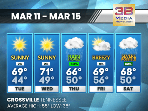
WARM AND SUNNY MIDWEEK BEFORE STORMS ARRIVE THIS WEEKEND
Mild temperatures and sunshine dominate through Wednesday, with increasing clouds and rain chances by Thursday. Strong storms and heavy rainfall are possible Saturday into Saturday
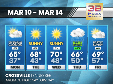
SUNNY START TO THE WEEK, SHOWERS POSSIBLE LATER
Clear skies and mild temperatures early in the week; rain chances increase by Thursday. Monday: Partly sunny, then gradually becoming sunny, with a high near 65.

WIND ADVISORY ISSUED FOR MIDDLE TENNESSEE
The National Weather Service has issued a Wind Advisory for Cumberland, Pickett, and Fentress counties from 10:00 PM CDT tonight until 7:00 AM CDT Saturday. Residents should prepare for south winds ra ...

FLOOD WATCH ISSUED FOR MULTIPLE COUNTIES THIS WEEKEND
From the Crossville/Cumberland County Emergency Management Agency: WHAT...Flooding caused by excessive rainfall is possible. * WHERE...A portion of Middle Tennessee, including the following countie ...

TENNESSEANS URGED TO TAKE STEPS AHEAD OF SEVERE STROM THREAT
NASHVILLE, Tenn. – The Tennessee Emergency Management Agency (TEMA) encourages all Tennesseans to monitor National Weather Service forecasts and take preparedness steps as multiple rounds of significa ...

SEVERE STORMS, TORNADO THREAT THIS WEEKEND
Severe thunderstorms expected Friday night through early Saturday morning, as well as Saturday afternoon and evening. Storms will pose a threat for damaging winds, large hail, flooding, and tornadoes. ...

STRONG THUNDERSTORM NEAR SPENCER; HAIL REPORTED
From the Crossville/Cumberland County Emergency Management Agency: At 101 PM CDT, Doppler radar was tracking a strong thunderstorm near Spencer, moving northeast at 15 mph. HAZARD...Wind gusts up t ...

SEVERE WEATHER THREAT THIS WEEKEND
A strong low-pressure system is set to bring severe weather to Middle and East Tennessee from Friday evening through Saturday night, with the potential for damaging storms, tornadoes, and heavy rainfa ...

STORMY WEEKEND AHEAD WITH SEVERE WEATHER POSSIBLE
A chance of showers Thursday, then a total lunar eclipse overnight—heavy rain and strong storms likely Saturday into Sunday before a cooler, sunny start to St. Patrick’s Day. Thursday: A chance of ...

SEVERE WEATHER UPDATE
Severe weather remains a concern for late Saturday, though some uncertainty still exists regarding the exact details. However, the latest trends indicate an increasing potential for a significant seve ...

WARM & SUNNY NOW – STORMS ARRIVE THIS WEEKEND!
Mild weather continues, a total lunar eclipse Thursday night, and weekend storms on the way! Today: Sunny, with a high near 72. Southwest wind 5 to 10 mph. Tonight: Increasing clouds, with a low ...

SEVERE WEATHER RISK SATURDAY
Chances for impactful weather have increased this weekend, especially from Saturday afternoon into Saturday night. Multiple rounds of storms are possible, bringing threats of damaging winds, tornadoes ...

WARM AND SUNNY MIDWEEK BEFORE STORMS ARRIVE THIS WEEKEND
Mild temperatures and sunshine dominate through Wednesday, with increasing clouds and rain chances by Thursday. Strong storms and heavy rainfall are possible Saturday into Saturday night. Tuesday: ...

SUNNY START TO THE WEEK, SHOWERS POSSIBLE LATER
Clear skies and mild temperatures early in the week; rain chances increase by Thursday. Monday: Partly sunny, then gradually becoming sunny, with a high near 65. North wind around 5 mph. Monday ...