
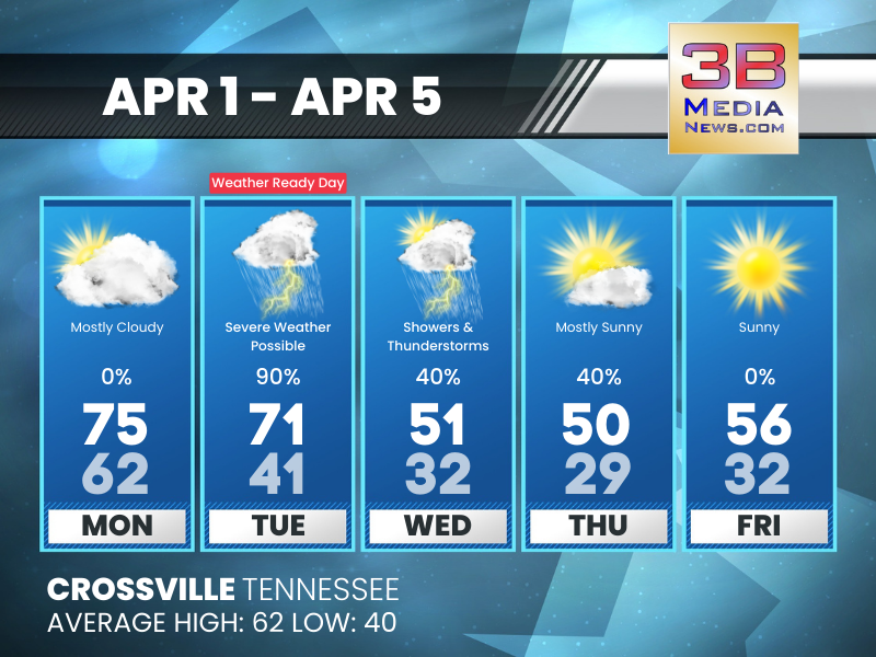
MONDAY’S 5-DAY FORECAST
WEATHER READY DAY: We continue to monitor the potential for scattered severe thunderstorms on Tuesday. Conditions appear favorable for some of the storms to produce damaging winds, large hail, and a f ...
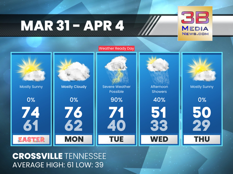
SUNDAY’S 5-DAY FORECAST
The main concern over the next 5 days continues to be on Tuesday. We have marked it as a Weather Ready Day. All modes of severe weather continue to look possible across Middle Tennessee and the Tennes ...
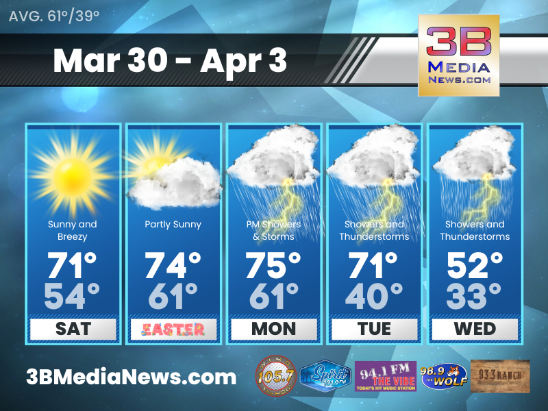
SATURDAY’S 5-DAY FORECAST
We are in the midst of a warming trend. It's looking warmer today with highs reaching into the 70s. Saturday: Sunny, with a high near 71. West southwest wind 10 to 15 mph, with gusts as high as 25 ...

FROST ADVISORY ISSUED
The National Weather Service has issued a Frost Advisory for portions of East Tennessee - including Blount, Morgan, Rhea, Meigs, Monroe, Roane, Loudon, Bledsoe, Anderson, and McMinn Counties in the 3B ...
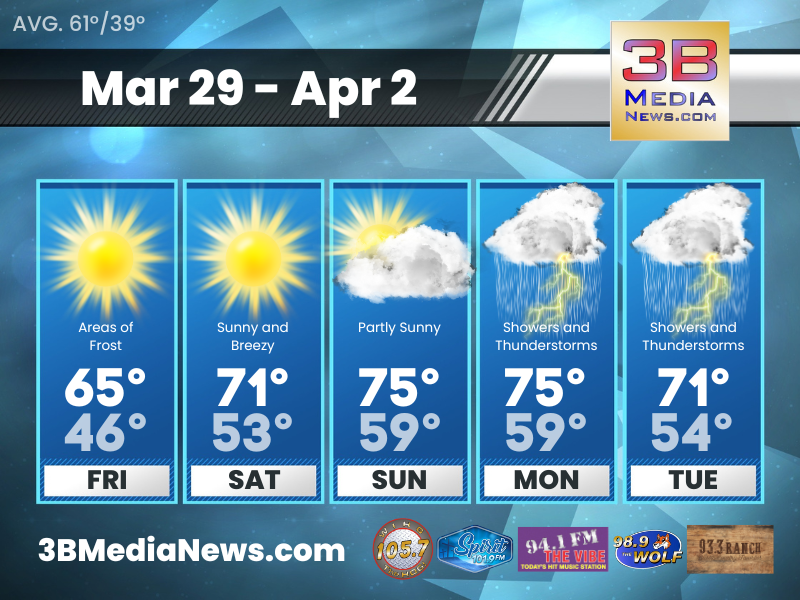
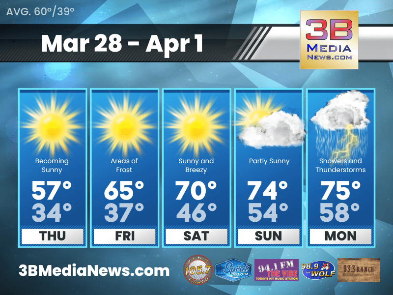
FRIDAY’S 5-DAY FORECAST
A big warmup is expected across the region through the weekend into early next week. Friday: Areas of frost before 8am. Otherwise, sunny, with a high near 65. West southwest wind 5 to 10 mph. Fr ...
THURSDAY’S 5-DAY FORECAST
FROST ADVISORY IN EFFECT FROM 3 AM TO 9 AM CDT THURSDAY Thursday: Mostly cloudy through mid morning, then gradual clearing, with a high near 58. North northeast wind around 10 mph, with gusts as hi ...

FROST ADVISORY
The National Weather Service has issued a Frost Advisory for a portion of Middle Tennessee - including Cumberland, Fentress, Pickett, and Morgan Counties in the 3B Media coverage area - from 3 AM to 9 ...

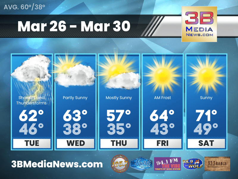
WEDNESDAY’S 5-DAY FORECAST
Dry conditions through Sunday. Wednesday: Mostly sunny, with a high near 62. Northwest wind 5 to 10 mph. Wednesday Night: Mostly cloudy, with a low around 37. North wind around 10 mph, with gust ...
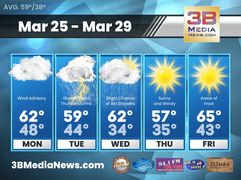
TUESDAY’S 5-DAY FORECAST
Seasonally warm conditions will continue to prevail through Tuesday afternoon. Tuesday: Showers and possibly a thunderstorm before 1pm, then showers likely. High near 60. South wind 15 to 20 mph, w ...

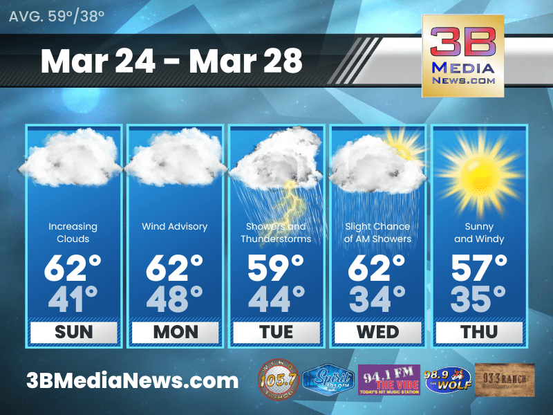
PLAN ON SECURING LOOSE ITEMS OUTSIDE AS A WIND ADVISORY IS IN EFFECT FOR OUR AREA
The National Weather Service has issued a WIND ADVISORY for parts of the Cumberland Plateau including the counties of Cumberland, Fentress, Pickett, Overton, Clay, Putnam, White, and Van Buren. The ...
MONDAY’S 5-DAY FORECAST
A Wind Advisory is in effect from 1 PM Monday to 7 AM CDT Tuesday for all of Middle Tennessee. Southeast winds 25 to 35 mph with gusts up to 55 mph expected. Monday: Mostly cloudy, with a high near ...
SUNDAY’S 5-DAY FORECAST
A Wind Advisory is in effect from 1 PM Monday to 7 AM CDT Tuesday for all of Middle Tennessee. Southeast winds 25 to 35 mph with gusts up to 55 mph expected. Today: Widespread frost before 7am. Oth ...