
POST-TROPICAL CYCLONE HERMINE HEADS TO EASTERN VIRGINIA, CONTINUES PATH TOWARD NYC AREA
Based on the current forecasts, Post-Tropical Cyclone Hermine is a storm without a good historical comparison. Hermine was once a tropical cyclone that made landfall in Florida, but that seems like ages ago. It has now transitioned to its post-tropical stage after moving northeast across land, off the coast of North Carolina, where it’s partially drawing energy from the jet stream. Hermine is forecast to affect the Mid-Atlantic over the next several days as a hurricane-strength storm, with a potentially historic coastal flood.
Of the 10 or so meteorologists I’ve talked to in the last day or so, none can recall Hermine’s rare combination: a hurricane that has transitioned to a post-tropical cyclone, one that is forecast to transition back into a hurricane and one that will stall just off the East Coast for most of a week. It probably hasn’t happened before, at least going back several decades.
But before we get to how weird and rare of a storm Hermine is, let’s highlight its forecast. Hermine won’t be as big or as powerful as 2012’s Hurricane Sandy, but its impact might be worse for some communities for a simple reason: It’s supposed to spend most of a week in roughly the same spot, just off the Mid-Atlantic coast.
Related Posts
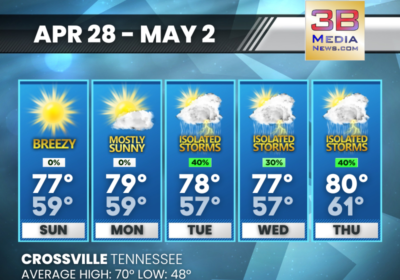
SUNDAY’S 5-DAY FORECAST
Dry through Monday, but then daily chances for at least scattered showers and thunderstorms through…
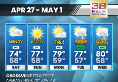
SATURDAY’S 5-DAY FORECAST
Winds continue to be breezy well into Saturday. Saturday: Partly sunny, with a high near 74.…

ARREST MADE IN ROANE COUNTY MURDER CASE
An investigation by special agents with the Tennessee Bureau of Investigation, the Roane County Sheriff’s…